OTOK RAB (CROATIA)
2005.05.21-28: History and Overview od Rab
2005.05.21-28: Gallery of the region and island
2005.05.21-28: External links
Welcome to the island of Rab!
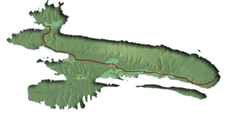 Italian ARBE (44° 45' N / 14° 46' E), island in the Adriatic Sea forming the northernmost part of Dalmatia in Croatia. Rab is separated from the mainland by Podvelebitski Kanal (the Velebit Channel) with the shortest distance from land of 1.800m. With an area of 91 sq. km, its greatest transverse length of 22km, and its total coastal length of 103.2km, it reaches a maximum altitude of 408m at Mt. Kamenjak and comprises three ridges of limestone./
Rab and all the Dalmatian islands were originally connected with the mainland; about 20.000 - 30.000 years ago, the lowering and elevating of the land and the penetration of the sea water into the basins resulted in the current island chain. The origin of the islands can be gleaned from their karst topography which is identical to that found in the craggy Dinaric Alps stretching from the eastern Adriatic and down to Greece.
The island is one of the most densely wooded islands in the Adriatic and is a veritable botanical exhibition, with plants not native to the island. The Komrcar park, with its laurel, poplar, cypress, Indian fig-tree, rosemary, pine and hundred-year-old agave is now the pride of Rab. Its more than 300 freshwater springs provide a valuable water supply to the population of the island--which, in contrast to most of the Adriatic islands, is increasing, in part because of good communications with the mainland. Because of these numerous springs, Rab is considered to be the greenest island in the Adriatic.
 Rab belongs to the group of Kvarner Archipelago Islands of the North Adriatic. Its winters are pleasant and mild, and the summers warm, with about 2500 hours of sunshine a year. The mean air temperature is 26C in the summer and 10 C in the winter. The Kamenjak range (408m) protects the greater part of the island from cold north-eastern winds (bora or bura), and the temperature hardly ever drops below zero (centigrade). In the summer the mistral wind has a cooling effect on the the island.
The best, the most comfortable and the most frequently used way of coming to the Rab island in case that you are coming in your own car or by bus is a ferry-boat line Jablanac-Mišnjak. Jablanac is a small town on the mainland, the nearest to the island of Rab, 105 km away from Rijeka, and only 6 km away from the Adriatic tourist road.
The turn from the Adriatic tourist road to Jablanac is visibly marked, and there is a place called Zivi Bunari 2.5 km nearer. Misnjak is a region in the Southeast of Rab. There are roads from Jablanac to Senj, Rijeka and further towards Western and Central Europe.
From Eastern Europe and the continental part of Croatia, it is best to use the direction of Zagreb-Karlovac-Rijeka-Senj or Zagreb-Karlovac- Josipdol-Brinje-Vratnik-Senj. The car-ferries go every day 10 to 20 times in both directions, and more if there is a need. In summer rides are more frequent, start at 5:30, and finish at 23:30, or later in case of traffic jams. The ride on this line is about 15 minutes long.
 A whole series of smaller islands makes part of the island of Rab, as well as the 27 cliffs and reefs surrounding it. To the extreme south of the "Podvelebitski kanal" (the Podvelebit channel) lies the small island Misnjak, and somewhat to the north the island Lukovac. The uninhabited island Dolin which on the western side stands athwarth between the southern part of the island of Rab and Pag in the "Paski kanal " (the Pag Channel) creates a lie in the "Barbatski kanal " (Barbat channel), appropriate for sailing and water sports.
The so called "Rapska vrata" (Rab narrows), leading form the Pag Channel to the "Uvala s. Eufemije" (St. Euphemia's bay) and the town port, extend from the north cape Dolina to the peninsula Frkanj on the western side of the island, vis-a-vis the town of Rab. Here, in front of the first of three marvellous coves which the islanders call Prva, Druga i Treca Padova (the First, Second and Third Padova) there is a green ornament in the azure blueness - the island of St. Juraj. Further on, in the open sea, in the sea area called Kvarneric, near the cape Lun on the island of Pag, there are some other nice small islands, rich in undersea flora and fauna: Veli and Mali Laganj, Trstenik, Mazunel and Veli and Mali Dolfin.
Navigation on the clear sea, along the indented southwestern coast of the island, along the parts called Suha Punta and Kalifront, continues up to the bays of Kampor and Gonar, on the opposite side of which lies the island Boljkovac, and then till the big bay Supetarska Draga, ornated by three green jewels: the small islands Maman, Sailovac and Sridnjak. To the extreme northeast, in the "Senjska vrata" (Senj narrows), close to the island Prvic, the big uninhabited island Grgur in the Podvelebit Channel, lies Goli otok. All these island complement the beauty and uniqueness of the main island, Rab.
Gallery (2005.05.21-28)
 |
") |
") |
|
Some maps |
Arrival (Senj) |
Apartmants Brna |
 |
 |
 |
|
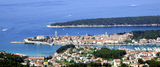
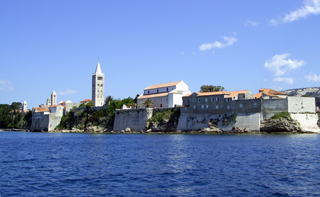
The city of Rab |
Panorama Kamenjak |
Kampor's Padovas |
 |
 |
 |
|
Plitvicka Jezera |
On sea, on the move... |
Best place of island... |
 |
||
|
Other fine pictures ... |